27-05-2008 - *bust* Chase Zuid-Limburg
Op basis van de verwachtingen Zuid-Limburg tot mijn doelgebied gekozen. Mijn vertrek was zo rond 13:30 en de situatie zag er eigenlijk een beetje zorgwekkend uit, het was nog maar 18.5°C en geheel bewolkt…
Op basis van de verwachtingen Zuid-Limburg tot mijn doelgebied gekozen. Ter referentie eerst maar eens kijken naar een gedeelte uit de Estofex forecast:
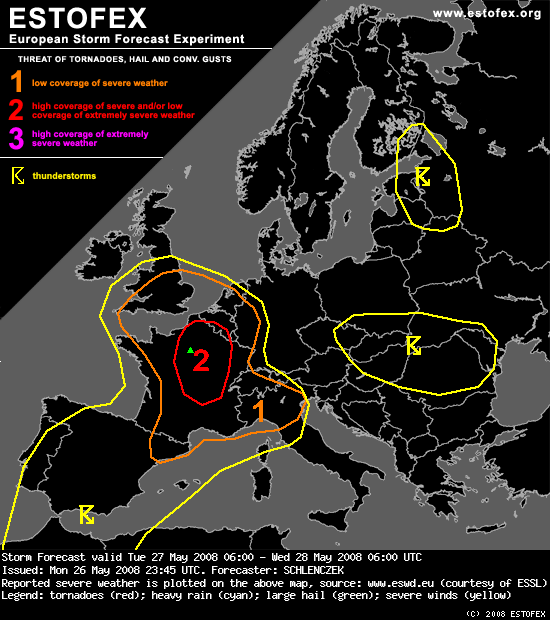
Bron: www.estofex.org
SYNOPSIS
On the east side of a large-scale upper trough over the Bay of Biscay, a shortwave trough will move northward into central France. Ahead of the shortwave, a 35 to 45 m/s jet streak at 300hPa points at central France. Another jet streak that belongs to this upper trough stretches from southern Ireland via Morocco towards northeastern Algeria with a speed max of 55 m/s at 300hPa. On the warm side of the jet streak, a plume of hot and moist air is advected northward and insolation as well as increasing BL moisture will create a significant amount of instability during the day. 12 UTC sounding of Munich on 26th May shows a well-defined EML and huge CAPE after reaching the convective temperature but the moist layer is very shallow within the warm sector airmass over Germany.
Between a stout ridge over the eastern-central Mediterranean and an upper low over southern Finland, a jet streak with 50 m/s at 300hPa, stretching from the southern Baltic Sea via Belarus and the western Ukraine towards northern Turkey, will translate eastward during the period. Scattered - probably non-severe - cold air convection with gusty winds and / or small hail is expected over southern Finland, Estonia, Latvia, northern Belarus and western Russia. Stable conditions will prevail over large portions of the central and eastern Mediterranean.
DISCUSSION
...Central France, Belgium, the Netherlands, southern UK, western Germany...
Around 06 UTC, GFS hints on a new MCS that may form over southern France in the morning hours while the old system over Belgium, the Netherlands and southern UK will likely decay. Surface dewpoints in the upper tens lead to moderate instability with about 1 kJ/kg MLCAPE over central France in the afternoon. A surface low ahead of the shortwave trough over southern France will induce a very strong wind field at lower levels on its eastern flank that should support convective cells in the whole level-two area. The limiting factor will be the stratiform precipitation and mid-level cloudiness that hinder insolation over parts of central France. GFS suggests that at least a small area over eastern-central France will have low cloudiness and more than 1 kJ/kg SBCAPE may form. Given 30 m/s deep layer shear and more than 400 J/kg SRH3, isolated storms will likely be supercellular and should be capable of producing large hail and isolated strong tornadoes as LLS exceeds 20 m/s in some places and strong SRH1 is present. If the convection develops more elevated, tornadoes should be rather unlikely but widespread severe gusts may occur as 850hPa wind field is well above 15 m/s and strong downdrafts will accelerate due to evaporative cooling. Strong QG forcing and 700hPa winds exceeding 30 m/s should be adequate for a severe squall line that develops during the afternoon / evening, capable of producing widespread severe gusts with some gusts exceeding 34 m/s. The line will translate northward across the level-two area and should reach southern UK, Belgium and the Netherlands in the late evening.
The airmass over western Germany is expected to be strongly capped but wind speeds near 15 m/s at lower levels could be strong enough for orographic lift, supported by some QG forcing as signalized by 500hPa Q-vector convergence. Moderate instability and up to 20 m/s deep layer shear will be adequate for organized multicells or supercells if indeed some convective cells develop. Other NWP models like NMM show some weak precip signals. Even though convective initiation is uncertain, western Germany is included in the level-one area.
As some uncertainties still remain, an update may follow later on.
Het leek me leuk (en comfortabel!) om bij m'n zus te Dieteren op bezoek te gaan en daar verdere ontwikkelingen af te wachten. Mijn vertrek was zo rond 13:30 en de situatie zag er eigenlijk een beetje zorgwekkend uit, het was nog maar 18.5°C en geheel bewolkt. Ik stop even bij tankstation Bossershof (da's dan al ter hoogte van St. Joost), de autothermo geeft inmiddels 22°C aan. Het treft me bij het uitstappen hoe enorm vochtig het is, het lijkt letterlijk of je natte handdoeken om je armen krijgt gelegd! Hieronder het temperatuurkaartje van 16:00, het is duidelijk dat de temperatuur een graad of vijf achterblijft bij wat voor deze regio verwacht werd:
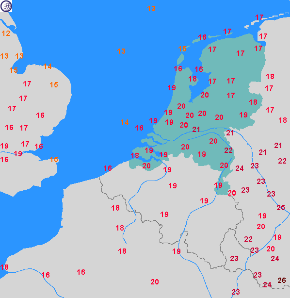
Bron: Weeronline.nl
Ik breng een paar gezellige uurtjes bij m'n zus door en dat is dan ook meteen alles wat ik verder te melden heb. Een dikke grijze stratiforme wolkendeken voorkomt verdere temperatuurstijging en er gebeurt helemaal niets. Rond 20:00 ben ik na 6,5 uur en 220km weer thuis, ik heb zelfs geen weerfoto gemaakt, er viel simpelweg niets te fotograferen... 😐
Geplaatst 08-10-2022 16:39
Gewijzigd 10-10-2022 17:36